Working Hard to Safeguard Paddling Assets for All Canadians

All about Whitewater

All about Whitewater
A Blog about River Preservation and the need to protect our free flowing whitewater resources

Wednesday, May 23, 2007

MINDEN: Frequently Asked Questions


What is the level of the Gull: how can I find the level from a guage?

Dave Ness, a PWGSC employee managing flows on the Trent Severn Waterway provided me recently with a stage flow table for the guage at the dam at the Minden Wildwater Preserve.

Dave Ness
Water Control Engineer
Trent-Severn Waterway
Telephone: 705 750-4902


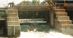
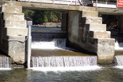
In this table, one converts the "stick" measurement into a flow measurement using a specific table. I am including a photograph of the stick at its location below the dam in the pool: The guy with the fishing rod is standing right next to it.


unfortunately... there is no online guage for this "STICK"

The number in the chart are "cubic meters per second". These are matched to the guage reading.


There is an online guage upstream at NORLAND

http://scitech.pyr.ec.gc.ca/waterweb/formNav.asp

search under "GULL AT NORLAND" and apply these conversions to their number to achieve release data on a cubic meters per second basis:


Here is the cms /cfs methodology

Note: 1 foot = 0.3048 meter

foot^3 per second = (foot x foot x foot) per second = (0.3048 meter x 0.3048 meter x 0.3048 meter) per second =
(0.3048 x 0.3048 x 0.3048 meter^3) per second = 0.028316846592 meter^3 per second.

So

1 cubic foot per second = 0.028316846592 cubic meter per second.


Where abouts is this preserve?

Minden, Ontario, north of Lindsey on Hwy 35

What river is it near?

The Gull River - part of the Trent Severn Waterway, controlled by Parks Canada (PWGSC)


Information available at the Kiosk: click on image


Cost to stay?

Member/non-member camping fees,

$8.00 members, $12.00 non members.

Yes, there are yearly passes.


This info is directed towards encouraging campers to pay up and why this is in their best long term interests,

General info regarding garbage disposal:

Pack it out with you. Do not leave garbage behind!!!!.


Good for any freestyle stuff or is it more of a running river?

River reading and running. Good surfing hole on top section for experts and strong intermediates.

Flow/Level Info: compliments of BOATWERKS!!!www.boatwerks.net/wl/
Gauge: below gauge


The gauge on the Gull is a stick-gauge, just down from the parking lot. There is not an accurate online gauge.


--------------------------------------------------------------------------------
Description:

The Gull is a short - 600m - section of continuous class 2-3 whitewater. It is a great river for practicing technical river-running skills and playboating. Where the river empties into Minden lake is one of the most popular learning spots in Southern Ontario.


--------------------------------------------------------------------------------
Directions:

GPS: N: 44 58.430 W: 78 32.519

From Minden go North to Horshoe Lk Rd. Turn rt and follow (3.5km) to parking lot on right. Put-in and take-out are within walking distance of the parking lot.


--------------------------------------------------------------------------------
Flow Information:

Low: runnable down to 4 cms, but starts to get bony around 8 cms.
Ideal: 18 cms and above - lots of water and good play
High: none. Routinely peaks above 40 cms in the spring.

Flow on the Gull is affected more by the dam than by natural runoff. This means that flows can change dramatically in a short time, based on how many logs get put in, or taken out on a particular day. The flow will rarely change dramatically over a weekend. Ironically, once summer season hits, the Gull often flows better in hot, dry conditions than it does in cool, moist conditions.
--------------------------------------------------------------------------------
Gauge info: this applies to the stick gauge just down from the parking lot. Use these #s to comvert the stick reading to flow (cms)

Gauge Flow
7.6 6.2
7.7 7.4
7.8 8.7
7.9 10.2
8.0 11.8
8.1 13.6
8.2 15.7
8.3 18.0
8.4 20.7
8.5 23.7
8.6 27.0
8.7 30.8
8.8 35.3
8.9 40.2

--------------------------------------------------------------------------------
Season:
Dam controlled, the Gull is paddleable year-round. January - March can see some big ice shelves in the eddies, but the river and the lake stay open 12 months. Most years, there is paddleable water all year with best flows from May - October.


Wanna check water levels from your cell phone?
levels page www.boatwerks.net/wl/


A MWWP promo blurb

Some numbers to consider. The Preserve ran at a $6000.00 deficit last season. We spent a bit more than previous years on maintanence. Our first weekend open and we had several campers - but not a penny in the money box. Someone left a huge bag of garbage on the ground beside the bin. This is a no trace camping area: ie garge is to be packed out.

For the moment we have a 100 percent rate of non payment for the first weekend of the summer. Keep in mind these dollar figures of past losses due to camping delinquencies,failure to pay their camping fees etc. People should be more responsible for using the preserve and make sure the other campers are paying for their stay. Users mst pay before they set up camp. Any customer that doesn't pay is not a customer, They are a thief and should be treated as such. Trespassers, non payers, may be reported to the police.

Its time to get back to the values of appreciation of someone doing something for you without feeling that this somehow entitles you to get a free ride and feel good about yourself, while taking advantage of the situation.
Volunteers put in a huge effort to make the park useful for paddlers. They volunteered huge hours but the first weekend of the season, we get a 100 percent non payment.

Provincial parks have no problem filling up their sites all summer. No provincial park is going to accept your IOU or the promise to buy a seasons pass later on. No honour system. They also charge twice to 3 times as much for the same kind of camping that you get at the Preserve. The big difference is the Preserve is very casual, you can bring your dog, drink anywhere you like, choose your site, come and go freely and get a good nights sleep. Most of those things are out when camping in provincial parks.

Minden provides camping along side an amazing river that wouldn't even exist if not for the foresight and hard work of previous WO members, yet folks regularily come and don't pay, leave exess garbage, generally take advantage and think no one notices or cares. By "dissing" or cheating or condeming WO paddlers are just short changing themselves. In the end WO is an idea or a concept that tries to further paddling needs, create a membership and maintain the Preserve and by extension the Gull River and it's history and future.


NEW SIGN for HARRINGTON PARK

SPONSORS WANTED

Public Meeting in Ville Marie

We are meeting with the public to discuss the Judicial Review and actions of Les Amis.

If you have contacts in the area would you care to promote this meeting for us?


Saturday, May 26th, École Frère Moffet (near of the Hospital) at 11h


The presentation will be about 45 minutes, with questions/discussions after the presentation,

duration: 1h-1h30

coffee and cookies refreshements available, books and Rally t-shirt, photos

Opémican map for discussion.

In the presentation:

-organisation (origin, members, why, when...) -the Kipawa river, wildlife animals, flora
-What Les Amis done, Kipawa trail, Rally, history of the implication of Les Amis, the book -presentation of the 2 hydroelectric projects, Hydro-Québec and algonquins)
-presentation of the Réserve de biodiversité projetée d'Opémican
-short Judicial Review presentation
-many photos, with map of the projects and Opémican


For now we have a newspaper ad with the invitation, if people in the region read the newspaper (I wish), they will read our invitation, we sent a email invitation to all the towns in the region(about 18 cities), invitations to all the media in the region (about 15), to the Société de Développement du Témiscamingue (20 employees), the SADC (Société d'Aide au Développement des Collectivités), the Carrefour jeunesse emploi, and all our personal contacts in the Témiscamingue.

We have put an invitation with the poster at Laniel, at the pedestral trail,
3-4 public places in Ville-Marie, and many dépanneurs in the citys near of Ville-Marie and Laniel (Guigues, Lorraiville, Béarn, Fabre), the region is big, so I don't go at all the 18 city in the region, we placed many invitations near Ville-Marie (35 km) and called the radio station to have some ad tomorrow and friday.

Its hard to believe people will drive more than 40-45 km to come, the region is very big...but we are hopeful.

I don,t know how many people will come, but if we have more than 20-25 people, I'll be happy.

Tuesday, May 22, 2007

Whitewater Ontario at Palmerfest 2007 05 19


Event and racebooks were handed out to approximately 200 newbies. I gave a brief address to the participants of the reel paddling film festival.

Pete

Canadian Rivers

Canadian Rivers
I speak for river users too!

The Queen is not amused!

The Queen is not amused!
http://www.ispeakforcanadianrivers.ca/

The Damned Dam - 2005 -

The Damned Dam - 2005 -
22nd Annual Kipaw Rally has modest turnout. - 23rd does better

The Ashlu river: it could happen to you

The Ashlu river: it could happen to you

Whitewater Ontario

Whitewater Ontario
Working Hard to Protect Canada's Paddling Resources

Whitewater Ontario - Mission Statement

It is Whitewater Ontario’s mission to support the whitewater paddling community through the promotion, development and growth of the sport in its various disciplines. We accomplish this through the development of events, resources, clubs, and programs for personal and athletic development, regardless of skill level or focus, to ensure a high standard of safety and competency; We advocate safe and environmentally responsible access and use of Ontario’s rivers. Whitewater Ontario is the sport governing body in the province, and represents provincial interests within the national body Whitewater Canada and the Canadian Canoe Association http://www.whitewaterontario.ca/page/mission.asp

Kipawa, Tabaret, and Opemican

Kipawa, Tabaret, and Opemican
If Hydro Quebec is not actively pursuing Tabaret what is that bite out of Opemican for?

Kipawa Dam: After

Kipawa Dam: After
Laniel Dam at 2006 Rally

Where is the Kipawa

Where is the Kipawa
Kipawa flows into lake Temiskamingue, running from Kipawa Lake, under hwy 101 in Quebec

Kipawa Dam

Kipawa Dam
laniel dam at 2004 River Rally

Tabaret is a Bad Idea

About the Kipawa


The best thing paddlers can do to help the cause of the Kipawa:

1. attend the rally and bring others including non paddlers to attend and buy beer and have fun

2. write your MP /MNA and raise the issue and post your objections -1 letter = 200 who didn't write

3. Write Thierry Vandal the CEO of Hydro Quebec strongly opposing the 132 MW standard decrying the use of "diversion" as the most environmentally inappropriate method of power production

4. Write Jean Charest, Premier of Quebec protesting that either the algonquin or the tabaret project will eliminate all other values on the Kipawa River by turning it into a dry gulch.

5. See if you can get other allied groups interested by showing your own interest, ie the Sierra Defense Fund, Earthwild, MEC, and so on.

6. Demand further consultation

7. Currently we are at the point where we need to sway public opinion and raise awareness.

However, if all else fails, don't get mad, simply disrupt, foment, and protest . The Monkey Wrench Gang.

Have you read Edward Abbey?

Important Addresses
CEO,Hydro Québec, 75 boul René Levesque, Montreal, P.Q., H2Z 1A4Caille.andre@hydro.qc.ca


Tabaret is a Bad Idea (Part Two)

Les Amis de la Riviere Kipawa is poised to use an application to the Federal Court to issue a Writ of Mandamus to ensure the Minster does what he is supposed to do, protect the public's right to navigate the water control structure at Laniel, Quebec using the Navigable Waters Protection Act. (see http://www.kipawariver.ca/)

In the now gutted Navigable Waters Protection Act lay the means by which the Minister of Transport could keep the public right of passage down our great Canadian Heritage, our rivers and streams which are threatened especially by resource corporations and power brokers such as Hydro Quebec.

These powerful entities continue to petition that 'this' river or 'that' stream is not navigable and therefore not protectable.
I don't say that dams and bridges should not be built, only that if they are, historical navigation rights should be considered and preserved by making reasonable accommodations for recreational boaters.

It is the Minister of Transport, in exercising the right to allow or disallow work on or over a navigable waterway is what keeps boats and recreational boaters plying our waterways.

To many recent cases launched in the Federal Court concerning the Navigable Waters Protection Act, most recently the case of the Humber Environment Group of Cornerbrook Newfoundland versus the Cornerbrook Pulp and Paper Company indicates that the important oversight is not being faithfully performed. Have we really come to the point now where we must say "such and such a stream is one foot deep, possessing so many cubic feet per second flow and so on?" The answer to this is... YES!

The honourable Mr. Justice John A. O'Keefe, ruled that it had not been shown that the river was navigable. How convenient was that to the Minister? But either the Minister of Transport acts to protect our rivers and streams as a public right or he does not and that means rivers and streams currently enjoyed by kayakers and canoists.

Enough of the cheating, and double-talk. Canadians! our rivers and streams are our own, lets urge the Minister of Transport and the our government to protect them.

Peter Karwacki

Tabaret is a Bad Idea (Part Three)

10 Reasons WhyTabaret is a Bad Idea1) Tabaret is too big. The station is designed to useevery drop of water available in the Kipawawatershed, but will run at only 44 percent capacity.We believe the Tabaret station is designed to usewater diverted from the Dumoine River into theKipawa watershed in the future. 2) The Tabaret project will eliminate the aquaticecosystem of the Kipawa River.The Tabaret project plan involves the diversion of a16-km section of the Kipawa River from its naturalstreambed into a new man-made outflow from LakeKipawa. 3) Tabaret will leave a large industrial footprint on thelandscape that will impact existing tourismoperations and eliminate future tourism potential. 4) The Tabaret project is an aggressive single-purposedevelopment, designed to maximize powergeneration at the expense of all other uses. 5) River-diversion, such as the Tabaret project, takinglarge amounts of water out of a river’s naturalstreambed and moving it to another place, is verydestructive to the natural environment. 6) The Kipawa River has been designated a protectedgreenspace in the region with severe limitations ondevelopment. This designation recognizes theecological, historical and natural heritage value ofthe river and the importance of protecting it.Tabaret will eliminate that value. 7) If necessary, there are other, smarter and morereasonable options for producing hydro power onthe Kipawa watershed. It is possible to build a lowimpactgenerating station on the Kipawa river, andmanage it as a “run-of-the-river” station, makinguse of natural flows while maintaining other values,with minimal impact on the environment. 8) The Kipawa watershed is a rich natural resource forthe Temiscaming Region, resonably close to largeurban areas, with huge untapped potential fortourism and recreation development in the future.Tabaret will severely reduce this potential. 9) Tabaret provides zero long-term economic benefitfor the region through employment. The plan is forthe station to be completely automated andremotely operated. 10) The Kipawa River is 12,000 years old. The riverwas here thousands of years before any peoplecame to the region. The Tabaret project will change all that.

Problems on a local River?

  • There is more to do as well but you have to do your research and above all, don't give up.
  • IN the meantime prepared a document itemizing the history of navigation of this spot and its recreational value. Use the Kipawa river history of navigation as a guide: see www.kipawariver.ca
  • Under the Ministry of Environment guidelines you have a set period of time to petition the change under the environmental bill of rights, you may have limited time to take this action. But it involves going to court for a judicial review of the decision.
  • 4. contact the ministry of natural resources officials and do the same thing.
  • 3. contact the ministry of the environment and determine if they approved the project
  • 2. determine if the dam was a legal dam, approved under the navigable waters protection act.
  • 1. research the decision and timing of it to determine if an environmental assessment was done.

Minden Ontario

Minden Ontario
Gull River Water control at Horseshoe lake

A History of Navigation on the Kipawa River

Prior to the environmental assessment there was no signage at the Laniel Dam

T-Shirts Area: These are available now!

T-Shirts Area: These are available now!
Send $25 and a stamped self addressed envelop for the Tshirt, and for the bumper sticker, a stamped and self addressed envelope with $5.00 for the bumper sticker to Les Amis de la rivière Kipawa, 80 Ontario St., Ottawa, Ontario, K1K 1K9 or click the link To purchase a Les Amis "T" contact Doug with the following information: Number of shirts:Sizes: Ship to Address: Method of Payment: cash, cheque and paypal, Shipto address:

Bumper Stickers Now Available

Bumper Stickers Now Available
Get your bumper sticker and show your support for the Kipawa Legal Fund ! - send $5.00 in a Stamped, self addressed envelope to: Peter Karwacki Box 39111, Ottawa, Ontario, Canada, K1H 7X0