
Minden, Gull River, Trent Severn Waterway issues
#1) Water Levels
-The only addition I would make is a point about obtaining releases for events. To purchase a release for Gull Fest, I was told that TSW only dealt with someone within WO to schedule those releases. Why is that? Can that change? What is the standard charge for obtaining releases?
Dam Releases are controlled by one person. There is good reason to establish a single contact to deal with Trent Severn on releases. One consistency and reliability in the person they are dealing with so that they know that person belongs to WO. Second any releases are scheduled on weekends and require overtime by Trent Severn personnel and the expense runs about $1000 per day as they open/close the Dam twice with two personnel. Third the releases need to be scheduled early in the year as Trent Severn sets out vacation for staff and is especially sensitive to calling up staff at last minute during the summer.
Most are satisfied for the most part with water levels over time. [we are concerned that possible changes might result in very poor water levels for whitewater navigation and race events etc.]
aware that levels have been more varied of late.
high water levels are not an issue unless flooding and damage will result [high and extremely high water levels are welcome thru this section and are not an issue unless they result in damage to Preserve riverbed]
#2) Information Exchange
we prefer more communication with TSW, both directions [benefits for TSW would be a more informed paddling community]
advance notice of dramatic variances when possible [the next 3 points would permit transfer of water level predictions which would also create rapport and build trust / credibility with the community]
access to gauge at Horseshoe Lake dam
access to overall Gull Watershed gauge info
see a need for more transparency with all watershed stakeholders as regards water levels
#3) Habitat Preservation
maintenance accommodation [ advance notice of low water periods would permit time to organize river clean up activity and maintenance of man made structures at Preserve
minimum flow in sensitive periods especially [protection of aquatic life as fishing is also popular above below and in the Preserve waters]
-If TSW agrees to provide more information related to water levels and management, how are we asking that they provide that info? Are we asking them to set something up on their website? There are several models for that, from the excellent resource of the Grand system, to the spotty info that OPG provides.We have always been able to get levels with a quick phone call.
-Same thing with advance notice of big changes: Who is it that gets that info? WO? What will they do with that info? The organisational time-line for doing riverbed work is so long that advance notice of low-water on the river would not affect that time-line.
-Again, same question about the gauge at the dam (which I don't think the water-control guys use: they still use the stick-gauge). Are we asking that the info go on-line? This would be cool, as there is no accurate on-line gauge for that stretch of river. The Norland gauge correlates, but only over long stretches of time.
All 3 points above need a 'who' and a 'how'. Is WO asking for access to the info? WO doesn't directly provide river levels, or links to any river level resources that I am aware of. If WO is asking, then I think there should be a plan for the dissemenation of the information. The only other option that I see is for the info to go on-line somewhere, either on a TSW website, or as part of the Environment Canada gauge pages.
- As opposed to asking for advance notice of dramatic changes - the time- line would likely be to short to allow for planning and getting the proper permissions - it would be interesting to ask if TSW would be willing to alter the levels when streambed work is scheduled. The last time we asked, there was not an overwhelmingly positive response.
Advance info on dramatic changes is what I think we would hope for. Not that all changes like this are predictable but many are. If high
water can be predicted or the end of high water this would be valuable to traveling paddlers. I realize predicting such things is witchcraft at
times but even a few days warning could divert people headed elsewhere into coming to the Gull or save them the trip. Either way TSW looks good in this kind of co-operation.
Releases to my knowledge are limited to 6 per year. They do seem to be grudgingly given out and are very valuable. I think $2600.00 for
an entire weekend and at minimum $800.00 for a single gate adjustment for day. WO has been able to secure a release for race events, I
think we (WO) have negotiated this ability many years ago and therefore WO is who TSW will deal with. I don't imagine they would feel compelled to deal with anyone else at this dam or any other.
I have no idea where TSW gathers level info from but it seems unlikely that they rely on a call made riverside by reading the stick. My
guess is the stick confirms info already imparted to the crew who comes out to make the change. The decision as to what the change will be must be made
somewhat in advance based on electronic gauge info. I'm guessing here. I just can't imagine with the technology we have these guy's are making seat
of the pants decisions on the fly. The stick likely serves to confirm and guide minor discretionary variations on the part of the crew in order to
meet a predetermined flow goal.
Whitewater Ontario is in the process of updating our website. The plan is to become more user friendly, more interactive with update ability
enhanced. We expect we'll soon be able to adjust and update our site easily and often. This is where I would like to see this info, if we can secure
it, posted and passed on to the public. I think in terms of acting as a liability buffer WO would be well suited to protect TSW from the concern that has
kept gauge and river info guarded by government organizations in the past. I don't know if our insurance policy is designed for this but I don't see how
passing on river levels is any worse than offering SRT courses that encourage participants to take very real risks. I expect we can bear the
liability concern very well.
SUMMATION
WO has been the traditional procurer of releases and is best positioned to continue doing so. (internally WO needs to do a better job of
letting people know how this works) Regarding info exchange we simply point out how more info passed
on to the river users is good for all involved. It is good public relations and beneficial to interested parties. If out of that we can get
occasional or regular info about level variations and even better, gauge access, then great.
Like the release deal WO is probably best positioned to handle information to be released publicly. Is there another organization that
could / should do this?
To my mind the key to WO improving it's image and functionality with regular paddlers is this kind of thing. We wouldn't be doing this if WO hadn't made the complaint and request for a meeting.. WO is the conduit / catalyst for this to work. It'll be up to us individually to keep the ball in the air if we're lucky enough to have TSW pass it to us.
Ongoing communication is key for any public service sector, and TSW is no exception. Having access to a gauge via the web would go a long way in PR for these guys with the public. If W.O. can facilitate that through our group, that will in turn, go a long way for W.O.'s image with the general paddling population as well.
using the W.O. banner is our best avenue. W.O.'s official status as an organization will legitimize our plight with TSW... ...though I would like to consider our group slightly more specialized with the best interests of the Gull river- Gull River Keepers.
annual schedule for river maintenance (if this is a priority)
Do we have some dates in mind, that would work with TSW's flows? With this we will have a better chance at actually accomplishing some of the physical things we would like to do to the Gull. The Gull River, cared for, well maintained and much used resource among cottagers, paddlers, fishermen and locals, the odds will be in our favor when it comes to ongoing and future river-bed maintenance and upkeep.
Any work done on the riverbed has been "Maintenance and erosion control with an eye towards user's safety and preserving fish habitat". I don't think altering the river for better play etc... is even worth mentioning to TSW. Many of our goals to modify the river for play and paddling specific features could and should fall under the 'River Maintenance'
category.
Mac Ellis
Mac was the supervisor of the dam-control team up here for many years - just retired a couple of years ago.RE: current conditions, as well as the availability of gauges.
Current conditions: Summed it up in one sentence "If you want water in the summer, it has to be held back now". Low snowpack, slow melt resulting in very little runoff, and a very dry spring (so far) have left TSW with very little water to work with.
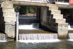
Gauges: The electronic gauge on the dam is apparently quite inaccurate since it measures pool height, not flow. The pool height is affected almost as much by which gates are running as it is by the actual flow of water. For that reason, they rely on the gauge at the parking lot for more accurate readings. There are very few electronic gauges on the system, due to poor quality phone lines (any "noise" on a phone line gets read as information).
increased access to gauges - push for getting the gauge updated and then put on the Environment Canada Realtime gauge page: that page is very easy to access and the precedent already exists for public access to river conditions. It is a great example of several management bodies - OPG, TSW, the Grand River Conservation Authority, Environment Canada - cooperating to offer a public resource. As well, the issue of liability due to access to gauge info has already been dealt with on that page. Once the info is on that page, anyone - WO, BoatWerks... - can link to it.
Water flow on the Gull Site is still measured off the stick on river right below the parking lot, that measurement is converted through a table calculation. You can call Trent Severn at anytime and get a recent reading. I think what people want is an online measurement in cms, that would take some doing and expense as would require special gauge and phoneline/net connectivity. Perhaps the easiest way to handle would be for Trent Severn to post most recent measurements and the next least expensive way is for BoatWerks to learn how to take the measurement do the calculation and post it on the WO site in exchange for some commercial exposure.















No comments:
Post a Comment