Friday, June 15, 2012
Do you recognize this country?
1. Sanctioned rendition of Mahar Arar to Syrian for torture
2. Gag orders in the science departments
3. Prorogation of parliament
4. Contempt of Parliament
5. Closure on debates
6. Impossibly large omnibus bills
Some backward fascist state? No - its our beloved Canada
I need a doughnut!
Tuesday, June 12, 2012
River Information - Kipawa Rally
The Kipawa River
Rally
June 22st-24th,
2012, Laniel, P.Q
Distance: 16 km (10 miles) from the village
of Laniel to Lake Temiscamingue.
Difficulty: Class III-IV river rating, Class III-VI
individual rapids (volume dependent)
Gradient: 30 feet/mile Volume: 20 cms (740 cfs) to 357 cms (13,209 cfs)
Description:
The Kipawa River is one of
the best intermediate white water runs in eastern Canada. The first exploratory river trips on the
Kipawa were made in 1971 in an open canoe by Jose Mediavilla and Joseph Jacob,
both from Rouyn.
Runnable at all levels, the lower Kipawa
does not get above a Class III, with the exception of Pete's Dragon, the
middle three drops in Hollywood rapid (a tight
technical Class IV) run only at low to medium levels. The rapids were named by
Peter Karwacki and Doug Skeggs in 1985.
Put-Ins and Take-Outs:
Road access at five locations includes, the
Dam at Laniel, a roadside park at Hwy 101, and via Topping Road off Hwy 100
atBroken Bridge rapid , the Grande Chute (some walking required on a good
trail), and at the take-out next to Hollywood rapid at the Kipawa River Lodge
owned by Scott and Pat Sorenson of Orem, Utah, USA.
There are 16 named rapids found in
three identifiable sections:
- Section I ...The Upper (Dam to Highway
Park)
- Section II ...The Middle (Highway Park to Island Rapid) - Section III ...The Lower (Log Jam to Hollywood)
The Dam (Class VI unrunnable all
levels):****Exremely Dangerous – unrunnable.
Rock and Roll (Class III-IV+ level
dependent)
Walk around Rock and Roll on river right, it’s routinely walked by boaters who don't like its steep rocky character. Typically enter right of centre, just to the left of a couple of very small holes reacting to a rock shelf near the surface. Move right then straighten out to run a narrow deep water channel that passes to the right of all the big holes out in the middle. Move left, back to the centre of the drop as soon as you pass the big holes.
The alternative run at levels from very low
up to 140 or 150 cms, is to enter just left of centre and work river left down a slide drop so that you work
to the far river left of the rapid about half way through it, then run the
bottom half hugging the left shoreline through a steep, abrupt hole. This is an
easy run at low water when you can actually eddy out half way through. It gets
progressively tougher the more water there is.
Tumbling Dice (Class III all levels):
The river bends below Rock and Roll and narrows a bit signaling the start of a long easy rapid called Tumbling Dice. The second portion of the rapid has a very sweet surfing wave called the Two-Four Wave developing above 120 cms and at its best at levels between 140 and 220.
Tumbling Dice dog legs left and then into a
series of easy surf waves that end with
the beginning of a stretch of flat water that runs past a roadsite park area
on Hwy 101. The park is no longer
maintained but it is perfect for camping, very private, lots of parking, no
camping fees, no one’s been bothered yet.
Buttonhook (Class III-IV+ level dependent)
At low water, Buttonhook reveals Kipawa’s rocky river bed - you just pick your way down. At high water, people who aren't comfortable being in big pushy water, call this rapid a Class V. A large hole runs river left to center midway down. At levels above 80 run the classic line starts left of centre, move almost immediately to the centre, move right towards the bottom of the upper section to get to the big eddy on the corner. Run the bottom section starting right, then working left at lower water, and staying right at higher water.
Be sure to book a family
stay at the Kipawa
River Lodge!
Les Amis de la Rivière Kipawa, c/o Francois
Diebolt 5658 Rue beaulieu, Montreal Quebec, H4E 3E3
Huey, Duey and Louie (Class III all levels):
Three little drops, sometimes called Sex, Lies and Videotape are easy. There is a small play wave on the left in the second drop.
Broken Bridge (Class III all levels):
Beneath the logging access road bridge is a glassy 3-boat wave that just won't quit. Enter from either side. Attainment may be difficult now that the new bridge is installed but the wave is a pleasure to surf between 80 cms and 220.
Island Rapid (Class III all levels):
Below Broken bridge the river splits around an island. River left is easier. River right is runnable at all levels but gets a little rocky at low water and requires more care. The river flattens out for 500 m. after Island Rapid
Log Jam (Class III all levels):
The river steepens here. The upstream side of Log Jam Island is undercut.
Run with the main flow on the left side of Log Jam Island.
Pick a line just right of centre for a best results.
Zipper (Class III-IV level dependent):
Home of the biggest wave on the river. Run with the main flow around the left side of the river. At the corner, a shelf forms a hole on river right and a wave on river left which is sometimes rolling back on itself but is always runnable. At levels above 175 cms, this wave gets big. At levels above 220 cms, it gets huge and above 315 cms, its.. Really big. You tend to get pushed left where the shore is rocky. If the wave looks pushy, hit it moving left to right for best results.
Upper White Pine (Class III all levels):
This is a series of corners and waves that is home of a small but very popular surfing spot.
Lower White Pine (Class III all
levels):
Also know as Cattle Prod, this is a short steep frothy drop that is actually a five-foot ledge at low water. Good fun with diagonal waves and lots of quick action. Run left down the chute.
Picnic (Class III-VI level dependent):
Picnic, can be a problem above 100 cms. At 357 cms it can recirculate trees. At low water, pick a line and go. At medium to high water run from centre pushing right to hit right in the corner where the reactionary wave coming off the shore, joins with the edge of the big hole. Or run far left, careful for the ledge hole just below.
Le Grande Chute This is true Class VI so don't even think
about it.
Its a 90-foot waterfall with three Class IV-V drops above it which have have been run only at low water. The lower falls were recently run by the team of Brent Cooper, Mike McCubbin and Ben Aylsworth at very low water in 2001. The walk is on the right. At low water there is a tall shelf rock at the base of the waterfall that is used for diving into the deep flat pool below. WARNING: scout for debris collecting below the falls.
Elbow (Class III-IV+):
Below the Grande Chute is Elbow Rapid. At 130 cms a large hole develops at river right at the elbow where all the water is going.. At low water, just pick your way down. At medium to high water, start right and work immediately to the centre, and then to the left as you hit the corner. The objective is to make the big eddy on the left side of the river. The bottom section of Elbow (175m) is straight forward with waves and small holes.
Hollywood (Class IV-VI level
dependent):
Show time! Hollywood is a tough run, unfriendly to swimmers. At low water the rapid is runnable top to bottom. At all levels you can run from the top to take out above Pete's Dragon keeping in mind that you will need to get your boat into a small eddy river right in solid Class III+ water above a very serious drop. If you are not comfortable with that, best to do the carry right around the top of Hollywood else pause for a second above it every time to whisper to yourself ``ok, stay right, make the eddy" before starting out.
The middle section, Pete's Dragon,
has three drops. Run the first drop through a small chute on the right, through
a small but steep hole that can mess with your line a bit (the tail of the
Dragon) so most skirt the edge of this thing rather than punch it. Immediately follows the second drop. Run up
onto the rocky pillow on the right then let your boat turn a bit and slip slide
sideways to the left. You end up dropping down and bracing left onto a curling
reactionary then right on the rocky
slide in the last half of the second drop (the belly of the Dragon).
Typcially try to end up in the big eddy on
river right. The 10-12 foot fall is next (the mouth of the Dragon). The fall is
less of a plunge the further right you go, its been run everywhere up to about 75 cms. You decide.
At higher water take the short walk, river right, around
Pete's Dragon, then back in your boat for the bottom half of Hollywood.
Ferry out to the centre and then to the left side of the river. This is a
challenging run in big swirling, churning water with surprisingly energetic
waves in it. Run down the left side at the bottom, when most of the water is
trying to talk you into going right where a dynamic large hole, Davey Jones
Locker, has surprised a lot of paddlers. Beware the triangular rock at the
bottom river left – Scott’s Knob it pops up just when you think you’re done.
Cell Phones may be operable in the vicinity
of the Kipawa
Centre de santé de Témiscaming
180, rue Anvik, C. P. 760
Témiscaming (Québec) J0Z 3R0
Tél. : (819) 627-3385
Centre de santé Sainte-Famille
22, rue Notre-Dame Nord, C.P.
2000,Ville-Marie, Québec,J0Z 3W0
(819) 629-2420
Centre d'urgence 9-1-1
Be sure to buy gas, food and beer at the
Laniel Depaneur!
Camp 3 saisons inc.
http://www.3seasoncamp.t2u.com
2011, route 101, C.P 39
Laniel, (Québec), J0Z 2K0
(819) 634-2582, 627-3737 (Été/Summer)
Camp de la Baie Smith
2050, chemin du Ski
Laniel, (Québec), J0Z 2K0
(819) 627-9858, 634-2425
Chalets Diane enr.
1948, route 101
Laniel, (Québec), J0Z 2K0
(819) 634-2576
|
Subscribe to:
Comments (Atom)
Useful Links
- Mount Gox - Bitcoin exchange
- Reggie Middleton's Rapier Analysis
- Ontario Rivers Alliance
- Geodesic Dome Construction
- Canadian Disaster Preparedness
- Globe and Mail
- Chris' The Weekly Telegram
- Michael Rupert of CollapseNet
- Max Keiser
- Nicole Foss Blog - the automatic earth
- Peak Moment Discussions
- Scotia Mocatta Bullion Store
- Dimitry Orlov - Peak Moment Discussions
- Jims's ISFCR Blog
- Jenny Right Side Blog
- Scott Sorensen
Alternative Energy Sites I like
The Queen is not amused!

http://www.ispeakforcanadianrivers.ca/
The Ashlu river: it could happen to you

Whitewater Ontario

Working Hard to Protect Canada's Paddling Resources
Whitewater Ontario - Mission Statement
It is Whitewater Ontario’s mission to support the whitewater paddling community through the promotion, development and growth of the sport in its various disciplines.
We accomplish this through the development of events, resources, clubs, and programs for personal and athletic development, regardless of skill level or focus, to ensure a high standard of safety and competency;
We advocate safe and environmentally responsible access and use of Ontario’s rivers.
Whitewater Ontario is the sport governing body in the province, and represents provincial interests within the national body Whitewater Canada and the Canadian Canoe Association
http://www.whitewaterontario.ca/page/mission.asp
Kipawa, Tabaret, and Opemican
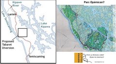
If Hydro Quebec is not actively pursuing Tabaret what is that bite out of Opemican for?
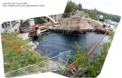
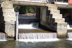
Kipawa Dam: After

Laniel Dam at 2006 Rally
Where is the Kipawa
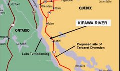
Kipawa flows into lake Temiskamingue, running from Kipawa Lake, under hwy 101 in Quebec
Kipawa Dam

laniel dam at 2004 River Rally
Tabaret is a Bad Idea
About the Kipawa
The best thing paddlers can do to help the cause of the Kipawa:
1. attend the rally and bring others including non paddlers to attend and buy beer and have fun
2. write your MP /MNA and raise the issue and post your objections -1 letter = 200 who didn't write
3. Write Thierry Vandal the CEO of Hydro Quebec strongly opposing the 132 MW standard decrying the use of "diversion" as the most environmentally inappropriate method of power production
4. Write Jean Charest, Premier of Quebec protesting that either the algonquin or the tabaret project will eliminate all other values on the Kipawa River by turning it into a dry gulch.
5. See if you can get other allied groups interested by showing your own interest, ie the Sierra Defense Fund, Earthwild, MEC, and so on.
6. Demand further consultation
7. Currently we are at the point where we need to sway public opinion and raise awareness.
However, if all else fails, don't get mad, simply disrupt, foment, and protest . The Monkey Wrench Gang.
Have you read Edward Abbey?
Important Addresses
CEO,Hydro Québec, 75 boul René Levesque, Montreal, P.Q., H2Z 1A4Caille.andre@hydro.qc.ca
Tabaret is a Bad Idea (Part Two)
Les Amis de la Riviere Kipawa is poised to use an application to the Federal Court to issue a Writ of Mandamus to ensure the Minster does what he is supposed to do, protect the public's right to navigate the water control structure at Laniel, Quebec using the Navigable Waters Protection Act. (see http://www.kipawariver.ca/)
In the now gutted Navigable Waters Protection Act lay the means by which the Minister of Transport could keep the public right of passage down our great Canadian Heritage, our rivers and streams which are threatened especially by resource corporations and power brokers such as Hydro Quebec.
These powerful entities continue to petition that 'this' river or 'that' stream is not navigable and therefore not protectable.
I don't say that dams and bridges should not be built, only that if they are, historical navigation rights should be considered and preserved by making reasonable accommodations for recreational boaters.
It is the Minister of Transport, in exercising the right to allow or disallow work on or over a navigable waterway is what keeps boats and recreational boaters plying our waterways.
To many recent cases launched in the Federal Court concerning the Navigable Waters Protection Act, most recently the case of the Humber Environment Group of Cornerbrook Newfoundland versus the Cornerbrook Pulp and Paper Company indicates that the important oversight is not being faithfully performed. Have we really come to the point now where we must say "such and such a stream is one foot deep, possessing so many cubic feet per second flow and so on?" The answer to this is... YES!
The honourable Mr. Justice John A. O'Keefe, ruled that it had not been shown that the river was navigable. How convenient was that to the Minister? But either the Minister of Transport acts to protect our rivers and streams as a public right or he does not and that means rivers and streams currently enjoyed by kayakers and canoists.
Enough of the cheating, and double-talk. Canadians! our rivers and streams are our own, lets urge the Minister of Transport and the our government to protect them.
Peter Karwacki
Tabaret is a Bad Idea (Part Three)
10 Reasons WhyTabaret is a Bad Idea1) Tabaret is too big. The station is designed to useevery drop of water available in the Kipawawatershed, but will run at only 44 percent capacity.We believe the Tabaret station is designed to usewater diverted from the Dumoine River into theKipawa watershed in the future.
2) The Tabaret project will eliminate the aquaticecosystem of the Kipawa River.The Tabaret project plan involves the diversion of a16-km section of the Kipawa River from its naturalstreambed into a new man-made outflow from LakeKipawa.
3) Tabaret will leave a large industrial footprint on thelandscape that will impact existing tourismoperations and eliminate future tourism potential.
4) The Tabaret project is an aggressive single-purposedevelopment, designed to maximize powergeneration at the expense of all other uses.
5) River-diversion, such as the Tabaret project, takinglarge amounts of water out of a river’s naturalstreambed and moving it to another place, is verydestructive to the natural environment.
6) The Kipawa River has been designated a protectedgreenspace in the region with severe limitations ondevelopment. This designation recognizes theecological, historical and natural heritage value ofthe river and the importance of protecting it.Tabaret will eliminate that value.
7) If necessary, there are other, smarter and morereasonable options for producing hydro power onthe Kipawa watershed. It is possible to build a lowimpactgenerating station on the Kipawa river, andmanage it as a “run-of-the-river” station, makinguse of natural flows while maintaining other values,with minimal impact on the environment.
8) The Kipawa watershed is a rich natural resource forthe Temiscaming Region, resonably close to largeurban areas, with huge untapped potential fortourism and recreation development in the future.Tabaret will severely reduce this potential.
9) Tabaret provides zero long-term economic benefitfor the region through employment. The plan is forthe station to be completely automated andremotely operated.
10) The Kipawa River is 12,000 years old. The riverwas here thousands of years before any peoplecame to the region. The Tabaret project will change all that.
Problems on a local River?
- There is more to do as well but you have to do your research and above all, don't give up.
- IN the meantime prepared a document itemizing the history of navigation of this spot and its recreational value. Use the Kipawa river history of navigation as a guide: see www.kipawariver.ca
- Under the Ministry of Environment guidelines you have a set period of time to petition the change under the environmental bill of rights, you may have limited time to take this action. But it involves going to court for a judicial review of the decision.
- 4. contact the ministry of natural resources officials and do the same thing.
- 3. contact the ministry of the environment and determine if they approved the project
- 2. determine if the dam was a legal dam, approved under the navigable waters protection act.
- 1. research the decision and timing of it to determine if an environmental assessment was done.
Minden Ontario
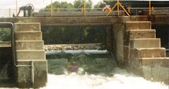
Gull River Water control at Horseshoe lake
A History of Navigation on the Kipawa River
Prior to the environmental assessment there was no signage at the Laniel Dam
T-Shirts Area: These are available now!

Send $25 and a stamped self addressed envelop for the Tshirt, and for the bumper sticker, a stamped and self addressed envelope with $5.00 for the bumper sticker to Les Amis de la rivière Kipawa, 80 Ontario St., Ottawa, Ontario, K1K 1K9 or click the link To purchase a Les Amis "T" contact Doug with the following information: Number of shirts:Sizes: Ship to Address: Method of Payment: cash, cheque and paypal, Shipto address:
Bumper Stickers Now Available

Get your bumper sticker and show your support for the Kipawa Legal Fund ! - send $5.00 in a Stamped, self addressed envelope to: Peter Karwacki Box 39111, Ottawa, Ontario, Canada, K1H 7X0


